
Mobile Apps For Backpackers: What Are The Best Digital Maps?

Applications for tourists are a tool for comfortable and effective interaction between a travel agency and a traveler. But undoubtedly, at the moment, there are such applications that should be not only in the smartphone of a traveler, but also in any resident of the metropolis.
To date, developers are actively working on backpacker apps, as this direction is very relevant in today's picture.
With backpacker apps, you can quickly navigate popular hiking trails.
A free trail application will help you not to get lost during bad weather and in case of an emergency, quickly go to your home.
An overview of mapping mobile apps for backpackers
For short and long hikers on easy routes located in popular tourist areas, it is imperative to install special backpacker apps on their phones to help them navigate the terrain and keep them on track. Such programs will help you to calculate the right time while hiking, mark important points along the route and quickly update information. The article will give a brief overview of such mobile applications that will help you quickly find an optimal route for a hike in an unfamiliar area, find a place to spend the night, an open natural reservoir and many other useful information for a tourist.
OpenStreetMap
It is a versatile app that can be used on hikes and in the city. The program is based on the OpenStreetMap mapping project, which uses individual GPS trackers and satellite imagery.
OpenStreetMap: the free wiki world mapIn such an application, a registered user can, if necessary, make changes to the mobile card, correcting its inaccuracies and erroneous data. Popular tourist routes are especially well described in these mobile maps. The program displays trails in forests and mountains, springs and broken camp sites. But with its help it is impossible to determine the degree of difficulty of the chosen route. A difficult pass can often be designated as an ordinary hiking trail, which an untrained beginner can easily overcome.
The application is presented in free and paid versions. The paid version of the program has more functions:
- display of high points on the route;
- additional ski and sea maps;
- offline sightseeing overview.
OsmAnd is best used on popular hiking trails. It offers several layers of geographic maps. If you load a map of the region into it, then you can use the program offline.
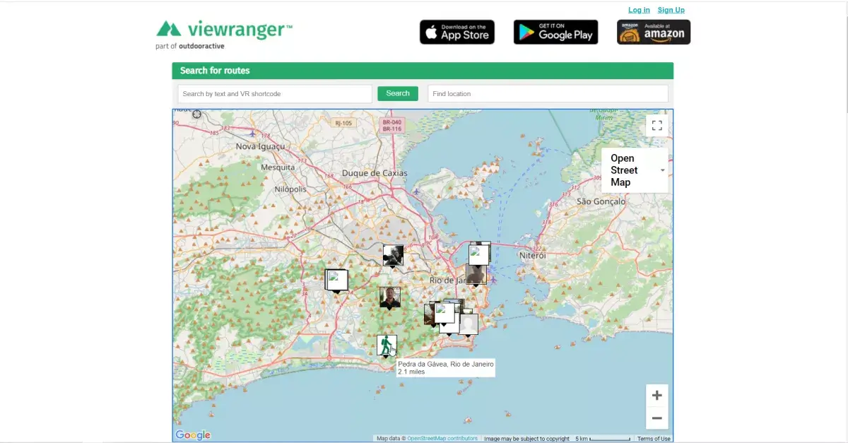
ViewRanger Mobile Maps
A universal tracking app that can be used on Android and iOS. It already contains ready-made routes, which, if desired, can be displayed on paper. The application can be used online and offline when there is no available internet and stable mobile connection. To do this, you need to download maps in GPX format. It should be borne in mind that this option is available only in the paid version of the application.
ViewRanger: Walking Routes, Hiking & Cycling Trails, GPS and OSMapsOn these virtual maps, the vegetation zone is clearly visible, there are built-in routes, the program allows you to quickly load and unload tracks. There is a mode of economical consumption of electricity. This application has significant drawbacks. The free trail app has significant limitations. It doesn't have a router. If mobile communication disappears, it will be impossible to use free cards.
It should also be noted that when loading a map, the program can often freeze when the map scale changes.
Locus Map mobile mapping application
Another app that backpackers can use on simple routes. It is designed for the Android platform only. A convenient app for backpackers has impressive functionality:
- provides the opportunity to plan a trip;
- it is possible to download maps of different scales, which can then be used on a hike;
- makes it possible to change and adjust the route;
- there are several layers of foreign and domestic map layers, with which you can work at different scales;
- there is a route planner and sightseeing overview.
The disadvantages of such an application include the presence of inaccuracies, the inability to use it in Apple mobile gadgets and the limitations of the free version of the program.
Locus Map - mobile outdoor navigation appMobile application Soviet military maps
When exploring mapping apps for backpackers, you should consider this Android-only program. It presents world and domestic geographical maps of the General Staff of Russia on a different scale. Maps allow you to determine the relief, the height of hills and ravines due to the fact that they are created on the basis of Soviet topographic maps. They even have objects that are not reflected on other maps. The specificity of such an application is that only those who understand the topographic designations used on military maps will be able to use such maps.
This free trail app allows you to record your route, but it doesn't have a navigation option. Therefore, those who will use Soviet military maps offline, without the Internet, will need to download and upload a route map of the required scale before the trip. Otherwise, it will be impossible to do this without access to the network.
It should also be noted that routes are not automatically created in this application, the free version has limitations and there are no new routes, since the application is built on Soviet military maps.
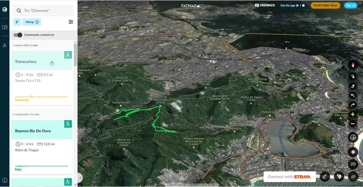
Fatmap mobile mapping application
This program with 3D maps can be downloaded on Android and iOS, in order to then view the terrain and data on the height and steepness of slopes, avalanche-prone areas in the mountains, find out information about the weather and snow conditions on the ski route. This program also has a section with important information for ski lovers, from which you can learn about ski resorts, slopes and lifts.
FATMAP: 3D Map & Guides for Skiing, Hiking and BikingHikers can also use such digital maps, since they describe the terrain in detail. The program allows you to use ready-made routes, as well as create your own individual tracks. The free trail app, like other programs of the same type, has significant limitations. Without a paid subscription, it will be impossible to access offline maps and information about weather data and snow conditions.
The program compiled for Russian routes also includes guides for Europe, Canada and America. The disadvantages also include the lack of a Russian version of this application.
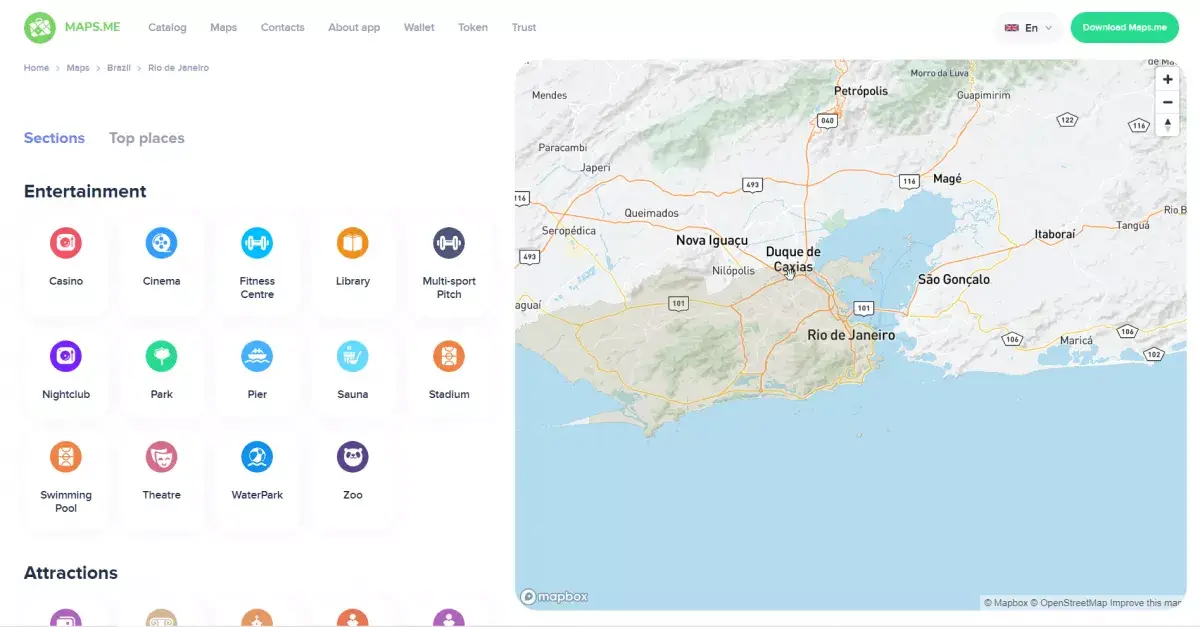
Mobile maps Maps.me
The application is suitable for Android and iOS. When it was based on OpenStreetMap maps, it was considered the best cartographic type program. The application was distinguished by the accuracy of the described routes, the presence of automatic automation and the ability to save the marked route points.
MAPS.ME (MapsWithMe), detailed offline maps of the worldAfter the rights to the program were sold to Daegu Limited in 2020, it became impossible to use the cards offline. So far, only the new owners of the service promise to fix the existing shortcomings of such a program. While you can work with old versions of the application, but if you install updates or download a new program, you will not be able to use the old functions.
What do backpackers need mobile maps for?
Beginners and even seasoned hikers can get lost in rugged terrain far from civilization. To prevent this from happening in the forest or in the mountains, you need to install special programs on your mobile gadgets that will help you navigate the terrain and choose the right route for your trip.
The presence of such a card guarantees that tourists will not get lost and will be able to quickly go to the source of water, parking lot, find the shortest way to nearby housing. The presence of a mobile application for backpackers on the phone is a guarantee of their safety during the hike.
Frequently Asked Questions
- How do digital map apps enhance the backpacking experience, and what key features should backpackers look for in these apps?
- Digital map apps enhance backpacking by providing detailed, up-to-date maps, GPS tracking, and route planning features. Backpackers should look for apps with offline access, user-friendly interfaces, and additional tools like elevation profiles and trail reviews.